Join 8,000 Iceland Travel Fans & Unlock Exclusive Discounts
Get Iceland advice straight from a local. Subscribe and unlock exclusive discounts from 50+ hand-picked Icelandic operators.- ✔ Instant access to exclusive discount codes
- ✔ Savings on tours, car, and camper rentals
- ✔ Tips and inspiration for planning your Iceland trip
Iceland has two very different routes called “Laugavegur” (“hot spring road”). One is the main shopping street in Reykjavik. The lower part of Laugavegur and Bankastræti, which follows it into the city center, are collectively and only half-jokingly called “Fleece Street” by us locals for all the tourist shops that sell Iceland memorabilia and weatherproof clothing. The Laugavegur Hiking Trail is a bit more interesting. In any case, please do yourself a favor and not restrict yourself to Laugavegur in Reykjavik when you visit Iceland!

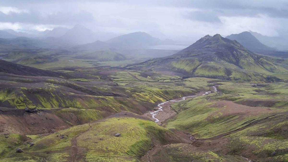
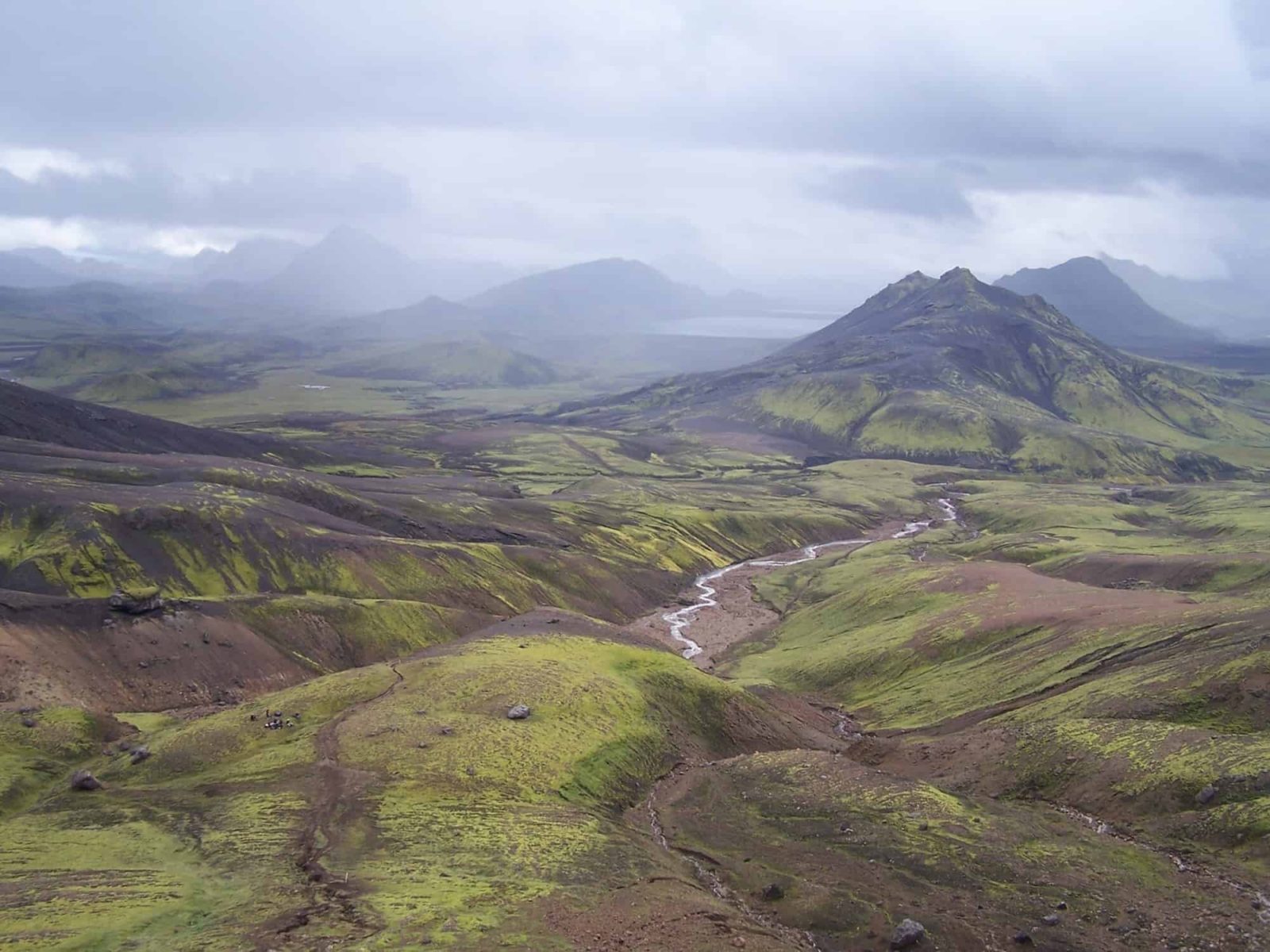
The Laugavegur hiking trail runs some 53KM from the thermal pools and the popular tourist destination of Landmannalaugar to the beautiful woodland of Þórsmörk (the forest of Thor). You can run it in one go (there is an annual Laugavegur ultra run) or you can be a bit more sensible, give it a few days, and stay in the huts along the way. The distance between the huts makes for a nice day of hiking, provided the weather is good. Along the way, you experience the best of the Icelandic highlands, the views are stunning, and the landscape is simply out of this world.

Stay safe, for goodness sake
This being the Icelandic highlands, there are no guarantees, so make sure you are prepared for whatever may come. Too many people are ignorant of the turns the weather can take up there. I remember talking to the caretaker in one of the huts, telling me that her main job consists of detaining jeans and sneakers-clad tourists with nothing more than stale muffins in a bag for food. They are just one rainstorm (or hailstorm) away from hypothermia.
More information on how to stay safe when traveling in Iceland

The Laugavegur hiking trail
The huts along the way should be considered milestones along the way. Overnight stays can be booked with the Icelandic Travel Association. >If you start at Landmannalaugar, the route can go something like this:

Landmannalaugar – Hrafntinnusker
This leg of the way is about 12 km, and it will take you some 4-5 hours. The elevation gain is about 470 meters. You start out at the lava field called Laugahraun, then proceed up the slopes of the “Brennisteinsalda” volcano, which has fantastic hues.
Hrafntinnusker – Álftavatn
This is another 12KM-long stretch of the way, and along the way descend some 490 meters. I know a lot of people will find it strange, but this is my favorite part of the way. Hrafntinnusker can be translated as “Obsidian Skerry,” and it is, well, full of beautiful, stark-looking obsidian.

Álftavatn – Emstrur
This takes some 15KM and takes some 6-7 hours on a good day. You descend some 40 meters. On the way, you cross into the Hvanngil ravine, and you wade across the small river of “Bratthálskvísl”. There are two huts in Hvanngil Ravine. You proceed south towards the strangely named place of Emstrur (Yes, I know that Bratthálskvísl is a mouthful as well!). After you wade across a second river, you come to a bridge across the river called Nyrðri Emstruá. If you have the chance, you should definitely go to the magnificent “Markarfljótsgljúfur” canyon, which is close to the huts at Emstrur.

Emstrur – Þórsmörk
The last leg takes us from Emstrur to the final destination at beloved Þórsmörk. It should take some 6-7 hours to hike the 15KM way. The descent along the way is some 300 meters. Much of the descent occurs when the Syðri – Emstruá canyon is tackled. In other words, the way down to the bridge across the river is really steep, so please be careful. The river Þröngá (literally “Tight River”) needs to be waded. After that is half an hour to Langidalur hut in Þórsmörk. Þórsmörk is a beautiful woodland area and a truly inviting place after the sometimes-cold desert of the Icelandic highlands.

More information on the Landmannalaugar hike
One way is to contact the Icelandic Travel Association for information on how to get to Landmannalaugar
Another great hiking trail is the Kjolur hiking trail
Did you enjoy this article?
Get more Iceland insight — straight from a local who's lived here his entire life
Join 8,000 travellers getting honest Iceland advice and unlock exclusive discount codes from 50+ hand-picked Icelandic operators.- ✔ Instant access to exclusive discount codes
- ✔ Savings on tours, car and camper rentals
- ✔ Tips and inspiration for planning your Iceland trip
No spam. Unsubscribe any time.